 Spatial Manager for AutoCAD Professional 9.1.2.15621
File size: 318.8 MB
Spatial Manager™ for AutoCAD is a powerful AutoCAD plug-in designed for AutoCAD users who need to import, export, transform and manage spatial data in a simple, fast and inexpensive way, which includes many functionalities not seen so far in AutoCAD.
It comes in a lightweight application that runs inside AutoCAD and allows the user to import and export geospatial data between AutoCAD drawings and geospatial files, data servers or data stores, display background maps, manage alphanumeric data and data tables, create terrain models and contours, search for locations, transform coordinate systems, and many more geospatial functionalities.
Key Features
Import spatial data into AutoCAD
Imports spatial data, into new or existing AutoCAD drawings, as AutoCAD objects and Extended Entity Data (EED/XDATA)
Export spatial data from AutoCAD
Export objects from the drawing to spatial files or databases, and saves their Extended Entity Data (EED/XDATA) as alphanumeric data tables
Coordinates transformation Updated V9
Calculate geometric transformations of the objects in the import and export processes
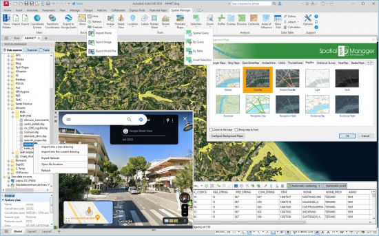
Background maps Updated V9
Choose from among a lot of dynamic Backgrounds Maps from providers such as Google Maps, OpenStreetMap, Bing, MapBox, Ordnance Survey, etc., configure your own maps from TMS, WMS or WMTS servers or connect to Cloud Optimized GeoTIFF (COG) type sources
Publishing to Google Earth
Export all or part of the objects in the visible Layers of the drawing and their data to a KML or KMZ file
Thematic maps
Visualize objects coloring them depending on their field values
 1 tuần trước


 Chế độ Linear

